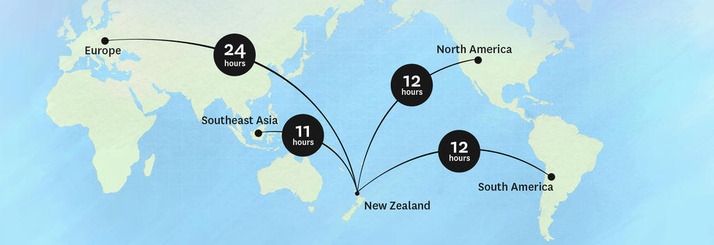
‹ Go to www.newzealand.com

Travel Planner for G&Y

Table of Contents

Disclaimer


Calendar

Day 1 - 22 March 2008

Christchurch

A city/town in the Christchurch - Canterbury Region

The South Island’s largest city, Christchurch is an entertaining mixture of refined lifestyle and cultural excitement. The tranquil Avon River meanders through the city, historic buildings house a lively arts community and restored trams make it easy for visitors to get around. The first four ships arrived from England to settle Christchurch in 1850, and their legacy lives on in the city’s grand heritage buildings and stately parks. Visit historic sites, museums and art galleries, and enjoy the highly developed restaurant scene. For an unforgettable scenic experience, travel up the Christchurch gondola or go punting on the Avon River.
Functional facts: Approx. population 317,000, international airport, three i-SITE visitor centres.

i-Sites in Christchurch

Christchurch Airport i-SITE Visitor Centre

Free itinerary planning and reservations service available 365 days a year for Christchurch, Canterbury and the rest of New Zealand.

Address: Domestic Terminal, Christchurch Airport, Christchurch
Phone: +64 +64 3 3537774
Fax: +64 +64 3 3537754
Email: christchurchairport@i-SITE.org

Christchurch i-SITE Visitor Centre

A National Visitor Information Centre - free advice and reservation service for all the unique attractions and activities in Christchurch, Canterbury and other regions.

Address: Old Chief Post Office, Cathedral Square West, Christchurch
Phone: +64 +64 3 3799629
Fax: +64 +64 3 3772424
Email: info@christchurchinformation.co.nz
Website: www.christchurchinformation.co.nz


Day 2 - 23 March 2008

Travelling from Christchurch to Takaka

Driving distance: 520km / 323 miles
Travel Times:

By road - Approximately 7 hours 34 minutes (By road)

By Air - Approximately 1 hour 40 minutes (By Air) + 19 minutes (By road)

By Rail - Approximately 5 hours 30 minutes (By Rail) + 3 hours 9 minutes (By road)

Takaka

A city/town in the Nelson Region

Takaka is located at the south eastern end of Golden Bay in the Nelson region. With a community that includes many alternative lifestylers, it’s a town full of character. There’s a small museum, a movie theatre and a great choice of shops and cafés. The town also offers plenty of value-for-money accommodation, including backpacker lodges, B & Bs and homestays. If you’re planning to hike in Kahurangi National Park, Takaka is a good place to take on essential supplies. Other nearby attractions include Waikoropupu Springs, the largest freshwater springs in New Zealand, and an art trail that will reveal the region’s creativity. Functional facts: Approx. population 1230, good range of shops and services, i-SITE Visitor Centre.

i-Sites in Takaka

Golden Bay i-SITE Visitor Centre

Information provision, accommodation, activities and travel bookings

Address: Willow Street, Golden Bay, Takaka
Phone: +64 +64 3 5259136
Fax: +64 +64 3 5259288
Email: goldenbay@i-SITE.org
Website: www.nelsonnz.com


Day 3 - 24 March 2008

Travelling from Takaka to Kaikoura

Driving distance: 356km / 221 miles
Travel Times:

By road - Approximately 5 hours (By road)

By Air - Approximately 1 hour 30 minutes (By Air) + 7 minutes (By road)

By Rail - Approximately 2 hours 38 minutes (By Rail) + 3 hours 9 minutes (By road)

Kaikoura

A city/town in the Christchurch - Canterbury Region

Kaikoura is a base for wildlife experiences of all kinds – it’s also a great place to eat crayfish (in the Maori language kai means food, koura means crayfish). The environment is truly spectacular – the village is caught between the rugged Seaward Kaikoura Range and the Pacific Ocean. In winter the mountains are covered with snow, adding to the drama of the landscape. Kaikoura’s special talent is marine mammal encounters – whales, fur seals and dolphins live permanently in the coastal waters. Whale watching trips leave the town several times a day and the local seal colony is always entertaining. There are plenty of cafés, restaurants and shops.
Functional facts: Approx. population 3800, i-SITE Visitor Centre, train station.

i-Sites in Kaikoura

Kaikoura i-SITE Visitor Centre

The Centre has been operating for 19 years and is the focal point in Kaikoura (population 3,800) for tourists and visitors who require information and booking services.

Address: West End, Kaikoura
Phone: +64 +64 3 3195641
Fax: +64 +64 3 3196819
Email: kaikoura@i-SITE.org
Website: www.kaikoura.co.nz

Travelling from Kaikoura to Motueka

Driving distance: 288km / 179 miles
Travel Times:

By road - Approximately 4 hours 1 minute (By road)

By Air - Approximately 1 hour 20 minutes (By Air) + 40 minutes (By road)

By Rail - Approximately 2 hours 38 minutes (By Rail) + 2 hours 10 minutes (By road)

Motueka

A city/town in the Nelson Region

Over the harvest months, Motueka is a busy town. The local pip fruit and hops growers employ seasonal labour which swells the population, and many visitors use the town as a supply point for explorations of the Abel Tasman and Kahurangi National Parks. The town has a small museum and there’s no shortage of interesting places to eat – you can even dine in a converted church in the main street. Motueka also has a lively artistic community, so the craft and art galleries are worth a look. Take a stroll along the waterfront walkway or drive to the Riwaka Resurgence, where the river emerges from a marble cave.
Functional facts: Approx. population 6600, visitors centre, good range of shops and services.

i-Sites in Motueka

Motueka i-SITE Visitor Centre

For accommodation, activity and travel bookings contact the Motueka Information Centre, Wallace Street, Motueka.

Address: Wallace Street, Motueka
Phone: +64 +64 3 5286543
Fax: +64 +64 3 5286563
Email: info@motuekaisite.co.nz
Website: www.motuekaisite.co.nz


Day 4 - 25 March 2008

Travelling from Motueka to Blenheim

Driving distance: 160km / 99 miles
Travel Times:

By road - Approximately 2 hours 10 minutes (By road)

By Air - Approximately 1 hour (By Air) + 42 minutes (By road)

Blenheim

A city/town in the Marlborough Region

Blenheim is situated in the heart of wine-growing Marlborough. It is one of the sunniest towns in New Zealand, with an estimated average of 2,438 hours of sunshine a year. Mountains frame the area and trap the summer heat (temperatures over 30°C are quite normal in February and March). In and around Blenheim you’ll find a pleasing selection of cafes, restaurants, bars, shops, artisan food outlets and golf courses. There are more than 20 wineries within driving distance of the town, and most of them welcome visitors for sampling sessions and cellar door sales. Character accommodation is a Blenheim speciality.
Functional facts: Approx. population 26,500, i-SITE Visitor Centre, domestic airport.

i-Sites in Blenheim

Blenheim i-SITE Visitor Centre

Blenheim i-SITE staff located in the historic Railway Station can arrange all your bookings for activities, accommodation and transportation to ensure that your Marlborough stay is a memorable one.

Address: Railway Station, Sinclair Street, Blenheim
Phone: +64 +64 3 5778080
Fax: +64 +64 3 5778079
Email: blenheim@i-SITE.org
Website: www.destinationmarlborough.com

Travelling from Blenheim to Picton

Driving distance: 28km / 17 miles
Travel Times:

By road - Approximately 24 minutes (By road)

By Rail - Approximately 30 minutes (By Rail)

Picton

A city/town in the Marlborough Region

The picturesque seaside town of Picton is the South Island base for the ferry service that links the main islands of New Zealand. It’s also the gateway to the marine, forest and island attractions of the Marlborough Sounds. Built around a very sheltered harbour, the town has an attractive seafront dotted with cafés, restaurants and various types of galleries. There’s also a floating maritime museum and an aquarium. Local operators can take you cruising, fishing, dolphin watching or sea kayaking. The Queen Charlotte Track is a major local attraction; you can conquer it on foot or on a mountain bike.
Functional facts: Approx. population 3600, i-SITE Visitor Centre, ferry services to and from the North Island.

i-Sites in Picton

Picton i-Site Visitor Centre

Picton Visitor Information Centre on the Foreshore, for bookings, accommodation and adventures in Marlborough and the Sounds, land and ferry transport.

Address: The Foreshore, Picton
Phone: +64 +64 3 5203113
Fax: +64 +64 3 5735021
Email: picton@i-SITE.org
Website: www.destinationmarlborough.com

Travelling from Picton to Renwick

Driving distance: 38km / 24 miles
Travel Times:

By road - Approximately 33 minutes (By road)

By Rail - Approximately 30 minutes (By Rail) + 9 minutes (By road)

Renwick

A city/town in the Marlborough Region

Sniff the air in Renwick and see if you can detect the scent of Sauvignon Blanc. This is wine country, where you can cycle from one vineyard to the next (bikes are available for hire). The town is small, but there are B & Bs, cottages and various other types of accommodation scattered around the district. Many of the wineries offer wine tasting as well as lunch and dinner. There is evidence that grapes were planted in the district as early as 1870, but it was only in the 1970s that the Marlborough phenomenon burst into life. 85% of New Zealand’s Sauvignon Blanc is grown here; Pinot Noir is the region’s other specialty.
Functional facts: Approx. population 1900, information centre, basic shops and services, domestic airport (Blenheim).


Day 6 - 27 March 2008

Travelling from Renwick to Nelson

Driving distance: 103km / 64 miles
Travel Times:

By road - Approximately 1 hour 20 minutes (By road)

By Air - Approximately 1 hour (By Air) + 8 minutes (By road)

Nelson

A city/town in the Nelson Region

Nelson is an entertaining city in many ways. From a cultural point of view, it provides the chance to appreciate New Zealand art, both in galleries and in artists’ studios. The district has attracted creative people who work with glass, metal, stone, wood, clay, sand, paper, ink, paint and fabric. Nelson is also appealing from a lifestyle point of view. There are wineries scattered around the Moutere Hills and the Waimea Plains. In the city, you’ll find a good selection of restaurants – some with huge views of Tasman Bay. Activities include skydiving, rock climbing, 4WD biking, horse treks, sailing charters and water fun at the excellent beaches.
Functional facts: Approx. population 52,300, i-SITE Visitor Centre, domestic airport.

i-Sites in Nelson

Nelson i-SITE Visitor Centre

Nelson i-SITE is your one-stop travel shop. We provide impartial comprehensive information and bookings on Nelson and New Zealand for activities, transport, and accommodation.

Address: Corner Trafalgar & Halifax Streets, Nelson
Phone: +64 +64 3 5482304
Fax: +64 +64 3 5467393
Email: Nelson@i-SITE.org
Website: www.i-SITENelsonNZ.com

Travelling from Nelson to Marahau

Driving distance: 65km / 40 miles
Travel Times:

By road - Approximately 57 minutes (By road)

Marahau

A city/town in the Nelson Region

Marahau guards the eastern entrance to the Abel Tasman National Park. Here you can book water taxis, hire kayaks or set off on the Coastal Track. The settlement offers a range of backpacker and self-contained accommodation; the camping grounds are very popular over the summer holiday season. Marahau's attractive beach offers safe swimming. For a memorable meal, make yourself comfortable at the local café – it has grand views of the beach and the national park. If you plan to stay overnight in the park, you’ll need to purchase hut/campsite tickets from the Department of Conservation (Takaka or Nelson) or the Motueka visitors centre.
Functional facts: Approx. population 500, limited shopping, water taxi service into park.

Abel Tasman Mountain Biking

Activity > Land Activities > Cycling/Mountain Biking in Marahau, Nelson Region

Abel Tasman Mountain Biking

Abel Tasman Mountain Biking offers single track, cross-country & downhill mountain biking on some of New Zealand’s finest trails through undisturbed subtropical native NZ rainforest, farmland and 4WD tracks.

Based in Marahau, the hub of Abel Tasman National Park activities, we have mountain bike access to inland sections of the park and private farmland of which we have exclusive consent - you can't do these trips elsewhere. You will take in incredible views, unspoiled landscape and take on the adrenalin.

From fully guided trips to freedom hires and multi-day, multi-activity options that combine overnight hut stays, sea kayaking, water taxis and walking - you will truly experience it all with Abel Tasman Mountain Biking. Open 7 days

Address: Franklin Street, Marahau
Phone: +64 +64 3 5278176
Fax: +64 +64 3 5278176
Email: enquiries@abeltasmanmountainbiking.co.nz
Website: www.abeltasmanmountainbiking.co.nz
View Full Details
 

Kahu Kayaks

Activity > Water Activities > Kayaking – Salt Water in Marahau, Nelson Region

Kahu Kayaks

Kahu Kayaks welcomes you to the Abel Tasman National Park, our golden piece of Aotearoa. Kahu Kayaks offers freedom rentals for those who wish to explore at their own pace and a great range of guided kayaking trips from our base in Marahau.

After years of experience in this industry our professional team will guide you on a great day out. Being locals, we know the Abel Tasman coastline like the back of our hands, which puts us in a great position to give you the best trip possible on the day. Not only will you have a great experience sea kayaking, but you will learn about the wildlife, history and Maori legends that make the Abel Tasman National Park such an intriguing and stunning coastline to kayak.

Qualmark Endorsed
Visitor Activity
Address: Sandy Bay Road, Marahau
Phone: +64 +64 3 5278300
Email: info@kahukayaks.co.nz
Website: www.kahukayaks.co.nz
View Full Details


Day 8 - 29 March 2008

Travelling from Marahau to Hokitika

Driving distance: 377km / 234 miles
Travel Times:

By road - Approximately 5 hours 30 minutes (By road)

By Air - Approximately 1 hour 25 minutes (By Air) + 54 minutes (By road)

By Rail - Approximately 10 hours (By Rail) + 3 hours 4 minutes (By road)

Hokitika

A city/town in the West Coast Region

Hokitika was first settled in 1860, after the discovery of gold on the west coast. It was an important river port, but many ships came to grief on the notorious ‘Hokitika Bar’ – a sandbar that shifts with every tide. There are some lovely old buildings on the town’s historic walk. You’ll also notice galleries specialising in pounamu jewellery and art works. The Arahura River, which enters the sea just north of Hokitika, is a traditional source of pounamu (greenstone). Gold jewellers, wood turners and potters provide other souvenir opportunities. Hokitika’s icon event is the Wildfoods Festival, which is held at the end of summer.
Functional facts: Approx. population 4000, i-SITE Visitor Centre, good range of shops and services.

i-Sites in Hokitika

Hokitika i-SITE Visitor Centre

Holidays are about new experiences, check it, book it, do it! Take the advice of the I-Site and you are guaranteed to get the best deal. We put you in the picture 100%

Address: Carnegie Building, Hamilton Street, Hokitika
Phone: +64 +64 3 755 6166
Fax: +64 +64 3 755 5011
Email: enquiries@hokitikainfo.co.nz


Day 9 - 30 March 2008

Travelling from Hokitika to Fox Glacier

Driving distance: 159km / 99 miles
Travel Times:

By road - Approximately 2 hours 18 minutes (By road)

Fox Glacier

A city/town in the West Coast Region

Named after Sir William Fox, New Zealand’s Prime Minister from 1869 to 1872, Fox Glacier describes both the glacier and the nearby village. Like its twin, Franz Josef, the glacier descends from the Southern Alps down into temperate rainforest just 300 metres above sea level. To see the glacier, you can walk to the terminal face, arrange an ice-hiking adventure or book a sightseeing flight. There are glow worm caves just a short walk from the town centre, which offers a good choice of cafes and restaurants. Close to Fox Glacier is beautiful Lake Matheson, one of the most photographed lakes in New Zealand (on a clear day it reflects Mount Cook).
Functional facts: Approx. population 280, Department of Conservation Visitor Centre, fuel.


Day 11 - 1 April 2008

Travelling from Fox Glacier to Hokitika

Driving distance: 159km / 99 miles
Travel Times:

By road - Approximately 2 hours 18 minutes (By road)

Hokitika

A city/town in the West Coast Region

Hokitika was first settled in 1860, after the discovery of gold on the west coast. It was an important river port, but many ships came to grief on the notorious ‘Hokitika Bar’ – a sandbar that shifts with every tide. There are some lovely old buildings on the town’s historic walk. You’ll also notice galleries specialising in pounamu jewellery and art works. The Arahura River, which enters the sea just north of Hokitika, is a traditional source of pounamu (greenstone). Gold jewellers, wood turners and potters provide other souvenir opportunities. Hokitika’s icon event is the Wildfoods Festival, which is held at the end of summer.
Functional facts: Approx. population 4000, i-SITE Visitor Centre, good range of shops and services.

i-Sites in Hokitika

Hokitika i-SITE Visitor Centre

Holidays are about new experiences, check it, book it, do it! Take the advice of the I-Site and you are guaranteed to get the best deal. We put you in the picture 100%

Address: Carnegie Building, Hamilton Street, Hokitika
Phone: +64 +64 3 755 6166
Fax: +64 +64 3 755 5011
Email: enquiries@hokitikainfo.co.nz


Day 14 - 4 April 2008

Travelling from Hokitika to Christchurch

Driving distance: 252km / 156 miles
Travel Times:

By road - Approximately 3 hours 21 minutes (By road)

By Air - Approximately 35 minutes (By Air) + 18 minutes (By road)

By Rail - Approximately 4 hours 30 minutes (By Rail) + 38 minutes (By road)

Christchurch

A city/town in the Christchurch - Canterbury Region

The South Island’s largest city, Christchurch is an entertaining mixture of refined lifestyle and cultural excitement. The tranquil Avon River meanders through the city, historic buildings house a lively arts community and restored trams make it easy for visitors to get around. The first four ships arrived from England to settle Christchurch in 1850, and their legacy lives on in the city’s grand heritage buildings and stately parks. Visit historic sites, museums and art galleries, and enjoy the highly developed restaurant scene. For an unforgettable scenic experience, travel up the Christchurch gondola or go punting on the Avon River.
Functional facts: Approx. population 317,000, international airport, three i-SITE visitor centres.

i-Sites in Christchurch

Christchurch Airport i-SITE Visitor Centre

Free itinerary planning and reservations service available 365 days a year for Christchurch, Canterbury and the rest of New Zealand.

Address: Domestic Terminal, Christchurch Airport, Christchurch
Phone: +64 +64 3 3537774
Fax: +64 +64 3 3537754
Email: christchurchairport@i-SITE.org

Christchurch i-SITE Visitor Centre

A National Visitor Information Centre - free advice and reservation service for all the unique attractions and activities in Christchurch, Canterbury and other regions.

Address: Old Chief Post Office, Cathedral Square West, Christchurch
Phone: +64 +64 3 3799629
Fax: +64 +64 3 3772424
Email: info@christchurchinformation.co.nz
Website: www.christchurchinformation.co.nz


Day 15 - 5 April 2008

Balloon Adventures Up Up and Away Ltd

Activity > Air Activities > Hot Air Ballooning in Christchurch, Christchurch - Canterbury Region

Balloon Adventures Up Up and Away Ltd

Fly in Christchurch with New Zealand's leading ballooning company. Christchurch's geography and climate are ideal for ballooning - they provide a unique situation where passengers can enjoy a superb view of the ocean, mountains and plains. Up Up and Away provides courtesy transfers from hotels for visitors staying in central Christchurch. Please allow 3-4 hours for your ballooning experience. Actual flying time is about one hour and passengers are encouraged to help in the flight preparation. As the sun rises, our flight takes us over a chequerboard of farmland laced with rivers, with the Southern Alps dominating the horizon to the west and the endless blue of the ocean to the east. After the flight we celebrate with a glass of Champagnes.

Address: Unit 6, 31 Stevens Street, Phillipstown, Christchurch
Phone: +64 +64 3 3814600
Fax: +64 +64 3 3814611
Email: info@ballooning.co.nz
Website: www.ballooning.co.nz
View Full Details


Collected items

Listed by Region

Nelson

Richmond

Richmond

A city/town in the Nelson Region

Just south of Nelson, the town of Richmond is a service centre for the farms, orchards and vineyards of the Waimea Plains. Pip fruit and berries are grown here, as well as hops for the beer industry. Richmond is a peaceful base for the region’s many attractions. From here you can discover wineries, beaches, art galleries, beautiful river valleys and horse treks. There are three national parks close at hand – Nelson Lakes, Abel Tasman and Kahurangi. The nearby Richmond Ranges are a great place for hiking and mountain biking. In winter you can ski at Rainbow Valley. Richmond has a comprehensive shopping area and a good choice of eating places.
Functional facts: Approx. population 2900, information centre, good range of shops and services.

St Arnaud

St Arnaud

A city/town in the Nelson Region

The village of St Arnaud sits at the edge of Lake Rotoiti in the Nelson region, providing an ideal base for people who plan to hike or fish in Nelson Lakes National Park. At the local Department of Conservation visitor centre you can learn about the ecology of honeydew beech forest; the centre can also provide guides to the local walks and treks, some of which take several days to complete. Both Lake Rotoroa and Lake Rotoiti are well known for their fine brown trout. Nearby Rainbow Ski Field is generally open from June to October. St Arnaud has a broad range of accommodation and a choice of eating places. Functional facts: Approx. population 200, limited shopping, service station.

West Coast

Franz Josef

Franz Josef

A city/town in the West Coast Region

Franz Josef Glacier was first explored in 1865 by geologist Julius von Haast, who named it after the Austrian emperor. The glacier is five kilometres from the town of the same name, and a 20 minute walk will take you to its terminal face. From the glacier car park, you can hike to a choice of lookout points for a bigger view of this awesome river of rice. If you want to actually make contact with the glacier, take a guided ice walk or a heli-hike. Aerial sightseeing is another option. In the town you’ll find plenty of places to stay and eat. At nearby Lake Mapourika there are kayaks for hire.
Functional facts: Approx. population 320, Department of Conservation Visitor Centre, fuel.

i-Sites in Franz Josef

Franz Josef i-SITE Visitor Centre - DOC Westland Tai Poutini National Park Visitor Centre & i-SITE

Curious about walks, what to do and see? Just ask us. Maps and brochures available. Discover the glaciers, find out why it rains so much, learn about our wildlife. Booking service available.

Address: Main Road, Franz Josef Glacier
Phone: +64 +64 3 7520796
Fax: +64 +64 3 7520797
Email: westlandnpvc@doc.govt.nz
Website: www.doc.govt.nz

Greymouth

Greymouth

A city/town in the West Coast Region

Once the site of the Maori pa Mawhera (which means ‘wide spread river mouth’, in reference to the town’s river mouth location), Greymouth is the largest town on the South Island’s west coast. The area has a history of gold mining, which can be appreciated at the local museum and nearby Shantytown. The local brewery is something of a New Zealand legend; it runs tours that include a tasting session. Other Greymouth entertainments include sea fishing, fly fishing, a quayside walk and hiking the Elizabeth Track, which passes through a scenic reserve and old goldmining sites. Around the town you’ll find galleries specialising in pounamu (New Zealand jade).
Functional facts: Approx. population 13,500, i-SITE Visitor Centre, train station.

i-Sites in Greymouth

Greymouth i-SITE Visitor Centre

Visitor Information Centre, situated in the centre of Greymouth. Able to assist with all enquires for the Grey District, which covers: Greymouth, Lake Brunner & Moana, Blackball and New Zealand.

Address: cnr Herbert & Mackay Street, Greymouth
Phone: +64 +64 3 7685101
Fax: +64 +64 3 7680317
Email: greymouth@i-SITE.org
Website: www.greydistrict.co.nz

Haast

Haast

A city/town in the West Coast Region

Named for German geologist Julius von Haast, the Haast area includes three settlements - Haast Junction, Haast Beach and Haast itself. You get the feeling you’re on the edge of the frontier - helicopters fly deer hunters into the rugged ranges and local pubs make a feature of mounted animal heads. The surrounding World Heritage Area is the main attraction here. Everywhere you look, Westland rainforest tumbles across the landscape. Haast entertainments include river safaris, visits to fur seal and penguin colonies, sea fishing, trout fishing, hunting and the drive to Jackson Bay, one of the most remote villages in New Zealand.
Functional facts: Approx. population 300, Department of Conservation Visitor Centre, limited shopping.

Karamea

Karamea

A city/town in the West Coast Region

Karamea sits at the end of a no-exit highway sandwiched between rainforested hills and the Tasman Sea. The town serves hikers and adventurers who are looking for a taste of New Zealand wilderness. Limestone arch formations are a special feature of the area. You can walk to the Oparara Arch, which spans the Oparara River, or venture further to find the Moria Gate Arch. To see the Honeycomb Hill Caves and Arch, you’ll need to book a guided tour. Karamea is near the southern entrance to the Heaphy Track, a multi-day walk through the Kahurangi National Park. Day walks include the Fenian Track, Mt Stormy and the first leg of the Wangapeka Track.
Functional facts: Approx. population 680, information centre, limited accommodation and shopping.

Punakaiki

Punakaiki

A city/town in the West Coast Region

The west coast settlement of Punakaiki is on the doorstep of the Paparoa National Park, which is full of secret caves, disappearing streams and river gorges. Punakaiki is also the closest population centre to the amazing Pancake Rocks and accompanying blowholes. The rocks are the result of a layering and weathering process; to see the blow holes in action, aim to visit around high tide. At Punakaiki you’ll find a variety of accommodation, from hostels and homestays to self-contained cottages; there’s also a range of eating places and galleries. Local operators provide horse treks, canoe hire, caving, guided walks and rafting adventures.
Functional facts: Approx. population 70, Department of Conservation Visitor Centre, limited shopping.

Westport

Westport

A city/town in the West Coast Region

Westport was first a gold town and then a coal town. The coal mining museum provides a glimpse of what it's like to work underground. Westport is also a centre for outdoor adventures – jet boating, underground rafting, caving, white water rafting and kayaking. Scenic highlights include old coal towns, goldmining relics, forest hikes and coastal walks. There is a seal colony nearby at Cape Foulwind. Depending on the season, there can be up to 100 New Zealand fur seals in the vicinity. Browse the local arts and crafts galleries – much of the work is produced locally.

Functional facts: Approx. population 4850, i-SITE Visitor Centre, good range of shops and services, plentiful accommodation.

Find out more at www.westport.org.nz

i-Sites in Westport

Westport i-Site Visitor Centre

Welcome to the Northern West Coast - the ultimate getaway experience where you can discover the real New Zealand. Get back to nature with our breathtaking scenery, beautiful walkways and beaches.

Address: 1 Brougham St, Westport
Phone: +64 +64 3 7896658
Email: westport@i-SITE.org
Website: www.westport.org.nz

Christchurch - Canterbury

Akaroa

Akaroa

A city/town in the Christchurch - Canterbury Region

Akaroa sits at the edge of a beautiful harbour inside the eroded crater of a huge extinct volcano. Originally a French settlement, the town is elegant and full of character. The streets have French names and local restaurants focus on French cuisine. The French settlers who arrived to establish the town in 1840 thought they were the first colonists of a new French territory, however the Treaty of Waitangi was signed just days before they arrived, which gave Britain sovereignty over the whole of New Zealand. Visit the Akaroa museum and take a self-guided walk to see historic cottages. Harbour cruises provide a chance to view dolphins, penguins and fur seals.
Functional facts: Approx. population 600, information centre, restaurants, bank.

Cheviot

Cheviot

A city/town in the Christchurch - Canterbury Region

Cheviot is the main town on the coastal route between Amberley and Kaikoura. Named for the Cheviot sheep, it’s clear that the primary local industry is wool growing. The museum depicts the history of the area, including the discovery of moa bones. Cheviot Hill Domain, with its extensive planting of English trees, is a pleasant picnic spot in all seasons. During summer months, Gore Bay on the coast is popular for surfing and both the Hurunui and Waiau Rivers reward fly fishermen with sea-run salmon and trout. If you’re not just passing through, a Cheviot farmstay can introduce you to the delights of sheep mustering, pony riding and other rural entertainments.
Functional facts: Approx. population 400, information board, limited accommodation.

Christchurch

Christchurch

A city/town in the Christchurch - Canterbury Region

The South Island’s largest city, Christchurch is an entertaining mixture of refined lifestyle and cultural excitement. The tranquil Avon River meanders through the city, historic buildings house a lively arts community and restored trams make it easy for visitors to get around. The first four ships arrived from England to settle Christchurch in 1850, and their legacy lives on in the city’s grand heritage buildings and stately parks. Visit historic sites, museums and art galleries, and enjoy the highly developed restaurant scene. For an unforgettable scenic experience, travel up the Christchurch gondola or go punting on the Avon River.
Functional facts: Approx. population 317,000, international airport, three i-SITE visitor centres.

i-Sites in Christchurch

Christchurch Airport i-SITE Visitor Centre

Free itinerary planning and reservations service available 365 days a year for Christchurch, Canterbury and the rest of New Zealand.

Address: Domestic Terminal, Christchurch Airport, Christchurch
Phone: +64 +64 3 3537774
Fax: +64 +64 3 3537754
Email: christchurchairport@i-SITE.org

Christchurch i-SITE Visitor Centre

A National Visitor Information Centre - free advice and reservation service for all the unique attractions and activities in Christchurch, Canterbury and other regions.

Address: Old Chief Post Office, Cathedral Square West, Christchurch
Phone: +64 +64 3 3799629
Fax: +64 +64 3 3772424
Email: info@christchurchinformation.co.nz
Website: www.christchurchinformation.co.nz

Ballymoney Farmstay and Garden

Accommodation > Farmstays in Christchurch, Christchurch - Canterbury Region

Ballymoney Farmstay and Garden

Ballymoney Farmstay is a country retreat in a two-acre rambling garden. It is a character farmhouse with king/twin ensuite and double bedrooms with private bathroom. There is also a self-contained garden suite with queen and single bed and ensuite bathroom.

Numerous extras are also available. We also offer seasonal cuisine featuring our own meat, eggs, fruits, nuts and vegetables, local fish and wine. Relax with our Irish/Kiwi hospitality. There are masses of animals and birds, many of rare breeds, on the farm. Farm tours on four-wheel motorbikes including animal feeding can be organised. Croquet, Bowles and bicycles on site. Golf and vineyards close by.

Price range: $NZ 170 - 220


Qualmark Rating
Address: Wardstay Road, Tai Tapu, Christchurch
Phone: +64 +64 3 3296706
Fax: +64 +64 3 3296709
Email: info@ballymoney.co.nz
Website: www.ballymoney.co.nz
View Full Details
 

Geraldine

Geraldine

A city/town in the Christchurch - Canterbury Region

The friendly village of Geraldine is in the heart of a prosperous farming area. The local people are mostly involved with sheep, cattle, deer, dairy cows, cropping and fruit growing, but the area is also known for its population of artists and crafts people. You can learn about the early history of the town at the Geraldine Historical Society Museum. The town also has a highly regarded vintage car and machinery museum. Another way to appreciate Geraldine is to walk the Historic Town Trail. Just beyond the town, you can visit gardens and artists’ studios. Sporting pursuits include skiing, white water rafting, golf and fishing.
Functional facts: Approx. population 2200, information centre, good range of shops and services.

i-Sites in Geraldine

Geraldine i-SITE

The friendly staff can assist you with information ,souvenirs and are booking agents for a wide range of activities , transport and accommodation.

Address: Corner Talbot & Cox Streets, Geraldine
Phone: +64 +64 3 6931006
Fax: +64 +64 3 6931008
Email: geraldine@i-SITE.org
Website: www.southisland.org.nz

Hanmer Springs

Hanmer Springs

A city/town in the Christchurch - Canterbury Region

Situated in the foothills of the Southern Alps, the resort town of Hanmer Springs is an attractive year-round holiday destination for adventure, relaxation and indulgence. Local activities are all about experiencing the beautiful environment. Go forest hiking, mountain biking, horse trekking, skiing (in winter), bungy jumping or jet boating. A round of golf (mini or regular) is another option. At the end of the day, head for the thermal reserve to soak in the naturally heated pools – or treat yourself to a range of indulgent spa therapies. There’s a modern shopping centre and plenty of choice when it comes to meal times.
Functional facts: Approx. population 750, visitor’s centre, good range of shops and services.

i-Sites in Hanmer Springs

Hurunui i-SITE Visitor Centre

Specialists in visitor information, packages and bookings for all activities, transport and accommodation in Hanmer Springs and the Hurunui District.

Address: 42 Amuri Avenue West, Hanmer Springs
Phone: +64 +64 3 315 0020
Freephone: +64 800 442 663
Fax: +64 +64 3 315 0021
Email: info@alpinepacifictourism.co.nz
Website: www.alpinepacifictourism.co.nz

Lake Tekapo

Lake Tekapo

A city/town in the Christchurch - Canterbury Region

Lake Tekapo and the other lakes in the Mackenzie Country are a wonderful opaque turquoise colour, the result of glacier-ground rock sediment in the water. The township at the lake’s edge knows how to look after visitors; it has a choice of cafes and several souvenir shops. The exquisite Church of the Good Shepherd is possibly the most photographed church in New Zealand - its altar window perfectly frames Mount Cook. Another photographic opportunity is the sheepdog memorial, which pays tribute to the role of dogs in high country farming. Make the most of the fresh, alpine air on the Lake Tekapo Walkway. On a clear night, you can watch the stars at Mt John Observatory.
Functional facts: Approx. population 300, food store, fuel.

Methven

Methven

A city/town in the Christchurch - Canterbury Region

Crouched at the base of the Southern Alps, one and a half hours inland from Christchurch, Methven is a welcoming town for visitors looking for adventure. In winter, it’s a base for snow sport enthusiasts who come to conquer the slopes of nearby Mount Hutt. At other times of the year, activities such as jet boating, sky diving, hot air ballooning and mountain biking are popular. If you enjoy fishing and golf, you won’t be disappointed with Methven. The town offers an excellent choice of eating places and bars. Accommodation ranges from backpacker lodges to character B & Bs.
Functional facts: Approx. population 1070, visitors centre, typical resort town shops and services.

i-Sites in Methven

Methven i-SITE Visitor Centre

Methven i-SITE Visitor Centre is part of the Visitor Information Network and can book transport, accommodation and attractions New Zealand wide.

Address: 121 Main Street, Methven
Phone: +64 +64 3 3028955
Fax: +64 +64 3 3028954
Email: methven@i-SITE.org
Website: www.methveninfo.co.nz

Aoraki (Hot Air) Balloon Safaris

Activity > Air Activities > Hot Air Ballooning in Methven, Christchurch - Canterbury Region

Aoraki (Hot Air) Balloon Safaris

Operating from Methven, “New Zealand’s Finest Ballooning Location”, pristine views are obtained of Mt. Cook and the National Park Mountains. Being very central over the Canterbury Plains, a full 300km panorama of the entire plains farm land is viewed from south of Timaru, to well north of Christchurch City. You can also view the world’s finest example of a braided river system, the Rakaia River. Commencing at daybreak, allow up to 4 hours, of which about 1 hour is the actual flight which concludes with a buffet “Champagne style breakfast”, offered as a picnic in the farmer’s field where the balloon lands. A non-flying ground fare is offered for any one who does not wish to fly in the balloon.

Address: 20 Barkers Rd, 7730, Methven
Phone: +64 +64 3 3028172
Fax: +64 +64 3 3028162
Email: aoraki@nzballooning.com
Website: www.nzballooning.com
View Full Details
 

Mt Cook Village

Mt Cook Village

A city/town in the Christchurch - Canterbury Region

The village of Mount Cook is a comfortable haven in one of the most unforgiving parts of New Zealand. On every side, the Southern Alps scrape the sky. Even in summer, the weather can change in the blink of an eye. The region is only 44 kilometres from the coast, so storms can arrive suddenly from the Tasman Sea to create dangerous conditions for climbers. However you don’t have to be a mountaineer to interact with the stunning scenery; there are various alpine walks beginning near the village, all about three hours return. Flightseeing, tours to the Tasman Glacier and heli-skiing (in winter) are other ways to optimise your time here.
Functional facts: Approx. population 250, Department of Conservation Visitor Centre, limited shopping.

Timaru

Timaru

A city/town in the Christchurch - Canterbury Region

The second largest city in Canterbury, Timaru sits about midway between Christchurch and Dunedin. It has everything you need for a pleasant stopover. Caroline Bay has a safe swimming beach, a maze, a landscaped piazza and walks. A collection of restaurants and cafés links the beach to the main shopping area. If you’re thirsty, consider a tour of the local brewery. The city’s excellent museum has moa-hunter artefacts and all kinds of whaling relics; the art gallery holds the third largest public art collection in the South Island. Timaru has many grand Victorian and Edwardian buildings, constructed in local volcanic bluestone.
Functional facts: Approx. population 27,350, i-SITE Visitor Centre, wide range of shops and services.

i-Sites in Timaru

Timaru i-SITE Visitor Information Centre

Visit the Timaru i-SITE for information on local activities and events. The friendly experienced staff can help you with all bookings for accommodation, activities and transport, 364 days per year..

Address: 2 George St, Timaru
Phone: +64 +64 3 6886163
Email: timaruinfo@southisland.org.nz
Website: www.southisland.org.nz/timaru.asp

Longview Farmstay

Accommodation > Farmstays in Timaru, Christchurch - Canterbury Region

Longview Farmstay

Longview Bed and Breakfast is Farmstay accommodation that offers magnificent panoramic views of the mountains, including Mt Hutt and Mt Dobson Ski fields. It is situated on 25 acres near the small township of Pleasant Point, and is 2hrs drive from Christchurch and 20 minutes from Timaru. Or if your time is limited, it is a great overnight stop en route to Aoraki / Mt Cook (180km) and Queenstown.

We have two queen size bedrooms and one room with twin beds. A full breakfast is included in the tariff.

Price range: $NZ 40 - 140

Address: 86 Longview Road, Pleasant Point, Timaru
Phone: +64 +64 3 6147766
Email: longview86@xtra.co.nz
Website: www.longviewfarmstay.co.nz
View Full Details
 

Twizel

Twizel

A city/town in the Christchurch - Canterbury Region

The town of Twizel was purpose-built in the 1960s to provide a home for workers involved with the Upper Waitaki Power Scheme. Today it is a well-positioned base for mountain climbing, kayaking, mountain biking, skiing, horse trekking and hiking. The peaks and trails of Mount Cook National Park are just up the road. You can fish for salmon and trout in the local rivers, canals and lakes. If you don’t have any luck, call into the salmon farm and buy a fish - fresh or smoked. In summer Twizel’s population more than trebles, as holiday houses and camp grounds fill to capacity.
Functional facts: Approx. population 1140, i-SITE Visitor Centre, good range of shops and accommodation.

Lake Wanaka

Wanaka

Wanaka

A city/town in the Lake Wanaka Region

The lakeside town of Wanaka can provide you with an appealing mix of fine living, family fun and adventure. It has a high concentration of cafes, restaurants and interesting shops. It’s obvious that the Wanaka district is nicely obsessed with aviation. At the airport you can arrange to go flightseeing or sky diving, and every two years the town hosts a spectacular airshow revolving around classic miliary aircraft. Winter is a busy time in Wanaka, as the town fills up with snow sports fans. Local snow venues include Treble Cone, Cardrona and Waiorau. Wanaka is also a handy base if you want to hike or climb in Mount Aspiring National Park.
Functional facts: Approx. population 3500, i-SITE Visitor Centre, wide range of accommodation.

i-Sites in Wanaka

Lake Wanaka i-SITE Visitor Centre

Booking agent for activities, transport and accommodation in Wanaka and throughout New Zealand. Selection of souvenirs.

Address: The Log Cabin, Lakefront, 100 Ardmore Street, Wanaka
Phone: +64 +64 3 4431233
Fax: +64 +64 3 4431290
Email: lakewanaka@i-SITE.org
Website: www.lakewanaka.co.nz

Queenstown

Arrowtown

Arrowtown

A city/town in the Queenstown Region

One of the most picturesque settlements in New Zealand, Arrowtown sits alongside the Arrow River – once the scene of a frantic gold rush. The town retains its historic character – there are more than 60 restored buildings from the 19th century. The gold days are long over (although you can still pan for gold in the river with some success), so Arrowtown's focus is on hosting visitors. Explore the Chinese miners’ settlement, visit the Lake District Museum, catch a few holes at the challenging local golf course or take a 4WD journey to Macetown, a ghost town accessible only by wagon track. Arrowtown has a range of cafes, restaurants and appealing shops.
Functional facts: Approx. population 1700, information centre, fuel.

Glenorchy

Glenorchy

A city/town in the Queenstown Region

The rustic town of Glenorchy, at the western end of Lake Wakatipu, is set against a background of native beech forest and towering snow-capped mountains. It is known as the gateway to the Routeburn, Caples, Greenstone, Rees and Dart Valley walking tracks. It’s also the place to organise jet boating and kayaking on the Dart River. Call into the Department of Conservation Visitor Centre if you plan to walk any of the tracks. Horse trekking in the area comes highly recommended. The town has an assortment of lodges, one hotel and a few cafés. It’s a good idea to buy hiking supplies in nearby Queenstown.
Functional facts: Approx. population 220, Department of Conservation Visitor Centre, fuel.

Queenstown

Queenstown

A city/town in the Queenstown Region

The resort town of Queenstown is sophisticated and fantastically scenic. Its lake and mountain landscape is suited to almost any kind of adventure; but Queenstown is just as well known as a place for indulgence. The area’s history is intertwined with gold. In 1862, two sheep shearers struck it rich at the edge of the Shotover River. The ensuing gold rush town was named Queenstown because '...it was fit for Queen Victoria'. Adventure activities include snow sports, bungy jumping, jet boating, horse trekking and river rafting. Indulgent experiences include exceptional food and wine, lake cruises, spa treatments, boutique shopping and leisurely games of golf.
Functional facts: Approx. population 7500, i-SITE Visitor Centre, domestic airport.

i-Sites in Queenstown

Queenstown i-SITE Visitor Centre

Our qualified Travel & Information Consultants can help you plan & book your activities, accommodation or transport throughout New Zealand.

Address: Clocktower Building, Cnr Shotover & Camp Street, Queenstown
Phone: +64 +64 3 442 4100
Freephone: +64 0800 668 888
Fax: +64 +64 3 442 8907
Email: info@qvc.co.nz
Website: www.queenstown-vacation.com

Central Otago

Alexandra

Alexandra

A city/town in the Central Otago Region

Alexandra is an attractive oasis of trees and civilisation within the weathered rock landscape of Central Otago. The town boomed during the late 1800s, when huge gold dredges worked the Clutha River. The most successful dredge was the Dunedin, which extracted an estimated 528kg of gold. Today Alexandra owes its prosperity to orchardists and wine makers. On foot or on a mountain bike, you can follow gold miner’s trails in the hills to appreciate the unique beauty of the area. You can also visit Pinot Noir vineyards and discover gold mining history at the museum. In summer and autumn, enjoy local apricots, peaches, cherries and apples.
Functional facts: Approx. population 4,500, i-SITE Visitor Centre, full range of shops and services.

i-Sites in Alexandra

Alexandra i-SITE Visitor Centre

Healthy adventure, recreation, good food and wine, striking scenery or some relaxing time in the sun - you'll find it in Central.

Address: 21 Centennial Avenue, Central Stories Bldg, Pioneer Park, Alexandra
Phone: +64 +64 3 4489515
Fax: +64 +64 3 4489511
Email: alexandra@i-SITE.org
Website: www.centralotagonz.com

Cromwell

Cromwell

A city/town in the Central Otago Region

Located on the shores of Lake Dunstan, Cromwell has the appearance of a modern town, but its history stretches back to the gold rush days of the 1800s. Cromwell underwent a major transformation in the 1980s, when parts of the town were flooded (on purpose) during the construction of the Clyde Dam power station. The best of the town’s historic buildings were relocated to create ‘Old Cromwell Town’ – a feature attraction for visitors. Today, Cromwell’s major industry is fruit growing – if you’re here over summer, roadside fruit stalls are a delicious temptation. Old gold mining sites include Bannockburn and Bendigo, where you’ll find ruins of miners’ cottages.
Functional facts: Approx. population 2700, i-SITE Visitor Centre, shopping centre.

i-Sites in Cromwell

Cromwell i-SITE Visitor Centre

Open 7 days a week, the Cromwell i-Site Visitors Centre should be the first call for any visitor to Cromwell and the Central Otago area.

Address: 47 The Mall, Cromwell
Phone: +64 +64 3 4450212
Fax: +64 +64 3 4451319
Email: cromwell@i-SITE.org
Website: www.cromwell.org.nz