
For a region made up of stunning landscapes, travelling around Canterbury is not just about the destination but the journey. Here’s some of the scenic highlights to hit along the way.
Canterbury covers a large part of the central-eastern South Island, extending from the Pacific coastline in the east to the Southern Alps in the west. Scenic highlights include the Southern Alps, Canterbury plains, and Pacific coastline – along with plenty of gentle rolling hillside in between. To help you plan your trip, here’s a few of highlights and suggestions on where to find more information.
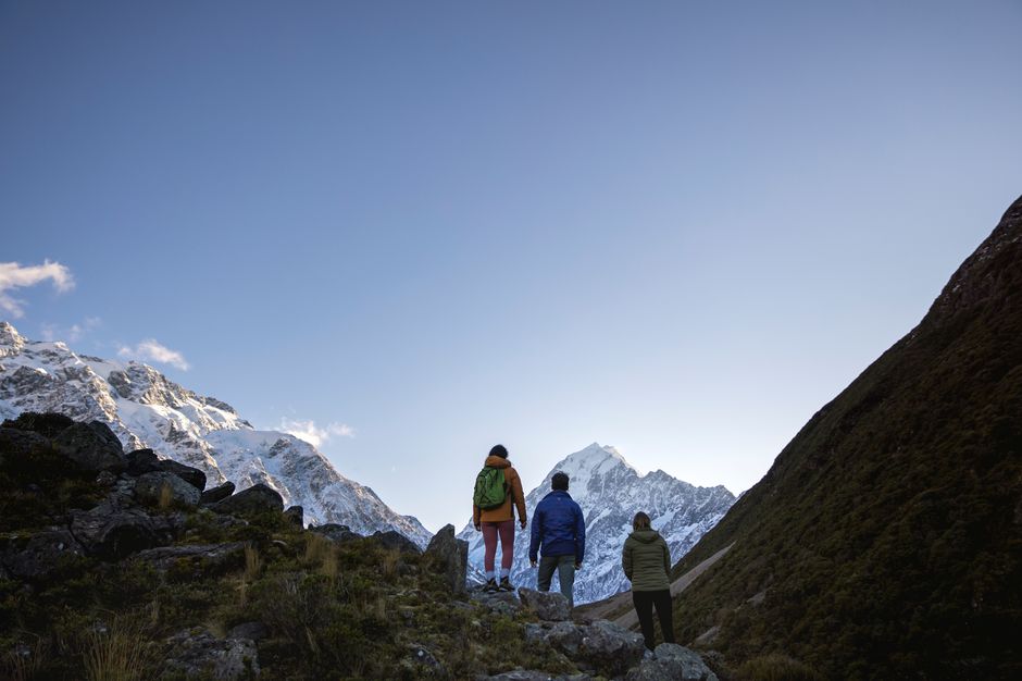
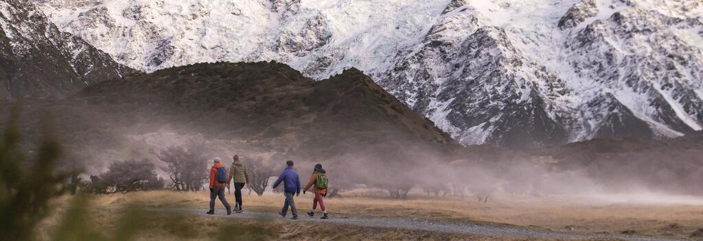
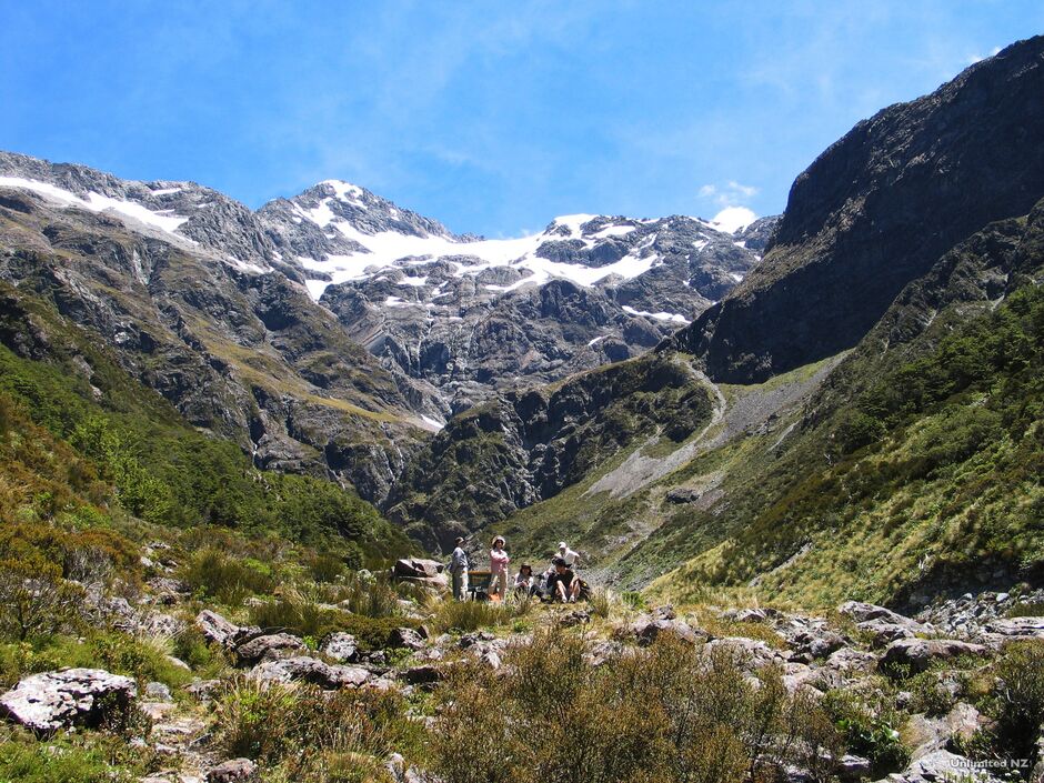
The extraordinary alpine landscapes of Aoraki/Mount Cook National Park are a gift – in more ways than one.
This spectacular national park is the ancestral land of Ngāi Tahu. In the 1990s, the government returned the park to Ngāi Tahu, as part of a settlement recognising the government’s historical breaches of the Treaty of Waitangi (New Zealand’s founding document). Ngāi Tahu then gifted the park to the people of New Zealand.
The region is home to some of the country’s most extreme alpine terrain, including Aotearoa New Zealand’s largest glacier and tallest mountain. But you don’t have to be a mountaineer enjoy it. There are plenty of short walks, designed to show off the region’s natural features. The Hooker Valley Track, Governors Bush Walk, and Kea Point Walk are great options. All take less than three hours, and provide excellent views of Aoraki/Mount Cook, the Hooker Glacier, and the Southern Alps.
This park is accessible from Queenstown, Christchurch and Hokitika airports.
Visit Aoraki/Mount Cook National Park visitor centre.(opens in new window)
Aoraki/Mount Cook National Park is not the only incredible attraction in the Mackenzie District. Visit Mackenzie Region(opens in new window) for more information.
Geothermal pools aren't the only attraction in this charming resort town, but you should still pack your swimsuit.
Hanmer Springs is famous for its geothermal hot springs, but it could equally be known for its outdoor attractions. Thanks to its remote alpine location, it is surrounded by mountains and rivers, making it a hotspot for jet boating, whitewater rafting, bungy jumping, mountain biking and hiking. In winter, you can add skiing to the list. To unwind from it all, take a drip in the hot pools at the end of the day.
Hanmer Springs is 70 km south-east of the Lewis Pass and a 90-minute drive from Ōtautahi Christchurch.
For a complete list of things to do, go to Visit Hurunui(opens in new window).
Kaikōura means ‘eat crayfish’ in the Māori language, which is good advice, but Kaikōura isn’t actually the town’s full name.
Its real name is Te Ahi-kai-koura-a-Tamatea-pokai-whenua, which translates as ‘the fire which Tamatea-pokai-whenua made to cook crayfish.’ It is named for the Polynesian explorer Tamatea, who upon discovering the bay did exactly as the name suggests.
By now, you've probably noticed a theme emerging. Lonely Planet once ranked the Kaikōura’s crayfish seventh in a list of the world’s top foods, ahead of pizza and dim sum. In this town, crayfish is sold everywhere, cooked in every possible way, from roadside barbeques and crayfish burgers to elegant dishes in fancy restaurants with price tags to match.
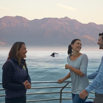
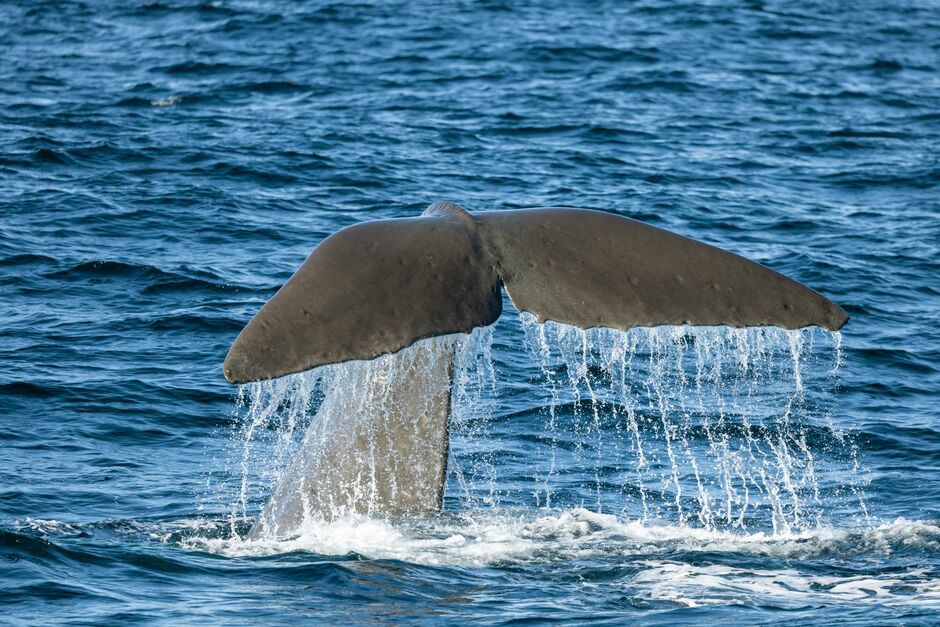
There’s more to Kaikōura than crayfish. Just off the coast is the Kaikōura Canyon, a 2,000-metre-deep ravine packed with marine life, including Sperm Whales, attracted by the rich feeding ground. To see these amazing creatures, your best bet is to take a tour on Whale Watch Kaikoura. Tours have a 95% success rate, and staff are experts at telling you the exact moment to take a photo – so you can capture a tail perfectly poised above the water, as the whale returns the ocean floor.
Kaikōura is also cock-full of amazing walking (and cycling) tracks that show off the region’s spectacular and varied scenery. Highlights include rugged headlands, steep sea-facing cliffs, ancient native forest, and snow-capped mountains. For short walks, try Hinau Walk, Kaikōura Peninsula Walkway and the Puhi Puhi Reserve Walk. For something more adventurous, hike to Mount Fyffe Hut or the Kaikōura Coast Track.
Kaikōura is in the northern-most part of Canterbury, a 2 1/2 hr drive from Ōtautahi Christchurch, or 2 hr drive from Picton.
For a complete list of things to do, go to Kaikuora.co.nz(opens in new window).
Taylor's Mistake is a picturesque bay on the outskirts of Christchurch. Who was Taylor and what was his mistake are two questions no-one can definitively answer – especially as there are three candidates for the title.
Until the late 1800s the bay was notorious for maritime incidents, with ships often mistaking the bay for Lyttleton Harbour. It is possible the first Taylor to make this mistake was not an official captain, but a Chief Officer, who took command of the Gwalior in 1853 after the tragic death of the ship's captain.
Until the 1980s Taylor’s Mistake was home to a small community of cave dwellers. You can still see remnants if the cave houses – around 19 in total – along the coastline from Taylor’s Mistake(opens in new window) to Boulder Bay.
Taylor’s Mistake is a 40-minute drive from Christchurch. A great way to see the area is to take the Awaroa/Godley Head Loop Track(opens in new window). It is a pleasant 3-hour walk, taking you from Taylor’s Mistake car park along the coast and back over the ridge, past the WWII Godley Head Gun Emplacements.
Arthur's Pass is an historic trading route through the Southern Alps. Although named for a surveyor called Arthur Dobson, this historic trading route was originally a route for Māori trading pounamu (greenstone) from the West Coast. Today, it is still the quickest route over the pass but also the gateway to the Arthur’s Pass National Park.
The Arthur’s Pass Walking Track is a gentle three-hour walk from Arthur’s Pass village to the Dobson Memorial at Arthur’s Pass summit. It showcases surprisingly varied scenery, including waterfalls, wetlands, and alpine forest, and see stunning mountain views.
Always check the weather forecast before you go. As an alpine region, the weather can change quickly. Even a beautiful sunny day can end in snow flurries.
Start the walk at the Punchbowl car park at the northern end of Arthur’s Pass village.
For more awesome adventures in Ōtautahi Christchurch, visit ChristchurchNZ(opens in new window).